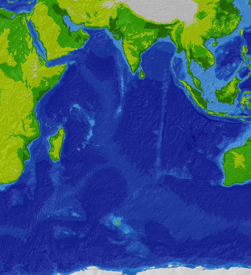
Catastrophe & Climate · South-west Indian Ocean, c. 1,500 km south-east of Madagascar

Burckle Crater & the Chevron Dunes

A claimed comet crater five kilometres down, giant 'tsunami dunes' on facing coasts, and a flood-myth date of 2807 BC — none of it accepted, all of it fascinating.

Mainstream: No confirmed impact — the seafloor feature is undated and unverified; the coastal 'chevron' dunes are wind-built over long periodsAlternative: c. 2800–3000 BC — proposed comet impact and megatsunami; Bruce Masse's flood-myth analysis dates it to 10 May 2807 BC-30.86°, 61.37°

At a glance

Burckle Crater & the Chevron Dunes
Photo: Cdc~commonswiki, SRTM30_plus data · CC BY-SA 3.0

Burckle Crater is a roughly 29-kilometre-wide depression on the floor of the south-west Indian Ocean, about 3,800 metres down, proposed in 2006 by Dallas Abbott of Columbia University's Lamont-Doherty Earth Observatory and the multinational Holocene Impact Working Group as the scar of a comet that struck within the last five thousand years. The group triangulated its position from enormous V-shaped 'chevron' dune deposits on the coasts of Madagascar and Western Australia, which they interpret as the run-up deposits of a megatsunami hundreds of metres high. Environmental archaeologist Bruce Masse went further, arguing that a global family of flood myths encodes eyewitness memory of the event and even fixes its date to May 2807 BC. Mainstream geology accepts neither the crater, the tsunami, nor the myth-derived date — making Burckle a textbook contest between pattern-seeking and proof.

See it on the globe →
The mainstream view

What archaeology says

Impact specialists point out that Burckle Crater fails every test normally required to confirm an impact structure: no shocked quartz, no shatter cones, no melt sheet, no ejecta layer traced to it, no geophysical survey demonstrating a crater form, and consequently no listing in the Earth Impact Database. A depression on rough, tectonically complex seafloor near the Southwest Indian Ridge can be volcanic or tectonic; a Holocene age has never been established by dating of any sample. Nicholas Pinter and Scott Ishman put the general objection sharply in a 2008 GSA Today essay, 'Impacts, mega-tsunami, and other extraordinary claims': statistically, impacts of this size should occur only about once every couple of hundred thousand years, yet the Holocene Impact Working Group's claims would require them every few thousand — extraordinary claims resting on evidence that has simpler, quieter explanations.

The chevron dunes received a direct test. In 2009 Jody Bourgeois of the University of Washington and tsunami modeller Robert Weiss showed that the Madagascan chevrons align with the prevailing south-easterly winds rather than radiating from Burckle, that modelled megatsunami behave nothing like the flows needed to build such forms, and that the deposits' sedimentology — including their fine, well-sorted sand — is classic aeolian dune material. Their paper's title said it all: 'Chevrons' are not mega-tsunami deposits. Subsequent dating work on Australian and Malagasy coastal dunes indicates accumulation over many millennia. As for the myths, historians of religion note that flood stories are near-universal because catastrophic river and coastal floods are near-universal; extracting a calendar date from them is, in the mainstream view, numerology rather than science.

Key evidence cited
  • Absence of shocked minerals, melt rock or verified ejecta — Burckle is not accepted by the Earth Impact Database
  • Bourgeois and Weiss (2009): chevrons align with prevailing winds, not with the proposed crater, and model as wind-built dunes
  • Sedimentology of the chevrons — fine, well-sorted sand typical of aeolian transport, not chaotic tsunami debris
  • Pinter and Ishman's statistical argument: kilometre-scale Holocene impacts are wildly improbable
  • Luminescence and stratigraphic dating suggesting the coastal dunes accumulated over many millennia
The alternative view

What the skeptics propose

Abbott and the Holocene Impact Working Group — which has included scientists from Russia, France, Australia and the United States — argue that oceanic impacts are systematically undercounted precisely because two-thirds of Earth's craters must lie underwater, where nobody looks. At Burckle they report supporting evidence from deep-sea sediment cores taken near the feature: fused nickel-iron droplets attached to foraminifera shells, carbonate hydrothermal minerals, and impact-consistent glassy fragments concentrated in young sediment barely blanketing the fresh-looking depression. The chevrons, they counter, contain shell and deep-water microfossils far above sea level and inland of any beach, sit on multiple coasts facing the proposed impact point, and are too large and too coarse in places for wind alone.

Bruce Masse, an environmental archaeologist at Los Alamos, supplied the boldest strand: analysing some 175 flood traditions worldwide, he argued that a cluster of details — a great darkness, torrential rain lasting days, a world-engulfing wave — describes a real oceanic comet impact, and that astronomical references embedded in Chinese, Mesopotamian and other accounts converge on 10 May 2807 BC. Proponents note this window broadly coincides with climate excursions and with the flood narratives of early urban civilisations from Sumer to the Indian Ocean rim. Even sympathetic reviewers concede the case is circumstantial, but the working group's core challenge retains force: until the deep seafloor is systematically surveyed and cored, the true Holocene impact rate is an assumption, not a measurement — and Burckle, they insist, deserves a dedicated coring expedition rather than dismissal from armchairs.

Key evidence cited
  • A fresh-looking 29 km seafloor depression with unusually thin sediment cover, suggesting geological youth
  • Reported nickel-iron droplets fused to foraminifera and impact-like debris in nearby deep-sea cores (Abbott et al.)
  • Marine shell and microfossils reported within chevron dunes well above and inland of modern shorelines
  • Chevron deposits on multiple Indian Ocean coasts whose axes proponents trace back towards Burckle
  • Masse's cross-cultural analysis of flood myths converging on a dated cataclysm around 2807 BC

Genuinely open questions

  1. What would a dedicated sonar and coring survey of the Burckle depression actually find?
  2. How common are unrecognised impact craters on the ocean floors, where surveying remains sparse?
  3. Why do the Madagascan chevrons contain marine microfossils — storm surge, older marine deposits, or something larger?

Worth knowing

Bruce Masse's proposed impact date of 10 May 2807 BC was derived partly from a Chinese flood myth mentioning a solar eclipse — making it perhaps the only crater ever 'dated' by mythology to a specific day.