What archaeology says
Scholars distinguish three layers that the modern legend compresses into one. First, the old texts: Sangam literature (roughly the early centuries AD) contains brief, sober references to a Pandyan king losing territory to the sea — the term kadatkol, 'seizure by the sea', is used — which historians read as memories of real coastal erosion, storm surges or tsunamis on a low-lying coast, of the kind the 2004 Indian Ocean tsunami made vivid. Second, the medieval elaboration: commentators such as Nakkirar (on the Iraiyanar Akapporul) and Adiyarkkunallar (on the Silappatikaram) expanded these losses into a grand scheme — three successive Sangam academies spanning nearly ten thousand years, the first two held at Tenmadurai and Kapatapuram in lands since drowned, with forty-nine districts submerged. Historians treat these accounts as literary legend-building that glorified the antiquity of Tamil letters, noting the impossible reign-lengths and the absence of any such geography in the earlier poems themselves.
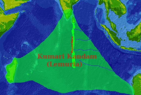
Third, the modern fusion, documented in detail by the cultural historian Sumathi Ramaswamy in The Lost Land of Lemuria (2004). From the 1890s, Tamil writers encountered Lemuria — by then already obsolete in geology — through colonial textbooks and Theosophy (whose world headquarters, not incidentally, sat at Adyar in Madras), and identified it with the drowned lands of the commentators. The name Kumari Kandam (from a Sanskrit-derived term in a medieval cosmological text) was applied, maps were drawn with rivers and cities, and the lost continent became a charter for Tamil cultural primacy: the first home of language, taught as fact in Tamil Nadu schoolbooks well into the later twentieth century. Geologically, plate tectonics rules out a foundered continent south of India just as it does elsewhere; what is real is the drowned continental shelf — at the Last Glacial Maximum, sea level stood some 120 metres lower, exposing land around India's southern tip and the Palk Strait (including the Adam's Bridge causeway area, dry until roughly 7,000 years ago), all gradually flooded as the ice melted.
- Plate tectonics and Indian Ocean bathymetry rule out any foundered continent south of India within human times
- The earliest Tamil references describe limited coastal land losses (kadatkol), not a continent; the grand scheme appears only in medieval commentaries
- The three-Sangam chronology, with academies lasting 4,400 and 3,700 years, is legendary in structure and unsupported by the surviving corpus
- The Kumari Kandam–Lemuria identification is documented as a 19th–20th century fusion (Sumathi Ramaswamy, The Lost Land of Lemuria)
- Real submergence is explained by post-glacial sea-level rise flooding the shelf and the Palk Strait by around 7,000 years ago