Belief & Society · Golan Heights

Rujm el-Hiri / Gilgal Refaim

A 40,000-tonne 'wheel of giants' on the Golan — whose famous solstice alignments may have quietly drifted off target.

Mainstream: c. 3600–2700 BC (Chalcolithic–Early Bronze Age; central cairn possibly later)Alternative: Date debated within archaeology itself — folklore and alternative writers instead tie the site to Og and the biblical giants of Bashan32.91°, 35.80°

At a glance

Rujm el-Hiri / Gilgal Refaim
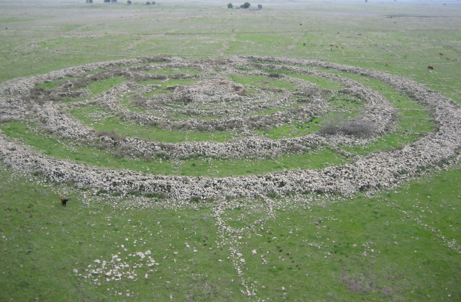
Photo: אסף.צ (Hebrew Wikipedia) · CC BY-SA 3.0 / GFDL

Rujm el-Hiri — Arabic for 'stone heap of the wild cat', known in Hebrew as Gilgal Refaim, 'wheel of giants' — is a vast megalithic complex on the Golan Heights plateau: four or five concentric basalt walls, the outermost about 150–160 metres across, converging on a central cairn some 4.5 metres high. An estimated 37,500–40,000 tonnes of loose basalt went into it. From the ground it reads as rubble; its true form was only recognised from aerial photographs examined in Israeli surveys after 1967. With no domestic remains inside and almost no datable finds, it is among the most enigmatic monuments in the Levant — routinely dubbed the 'Stonehenge of the East'.

See it on the globe →
The mainstream view

What archaeology says

The first systematic excavations were led by Yonathan Mizrachi over four seasons (1988–1991), with survey work under Moshe Kochavi; Michael Freikman and Yosef Garfinkel of the Hebrew University returned in 2007–2010. Pottery sherds and architectural parallels point to construction in the Chalcolithic to Early Bronze Age, with most scholars favouring Early Bronze II (c. 3000–2700 BC), though Freikman has argued the rings are Chalcolithic (c. 3900–3500 BC) and that the central burial cairn may have been added as much as a millennium later. The dolmen-strewn landscape around it belongs to the same broad megalithic tradition. As for purpose, proposals include a regional ceremonial centre, a burial monument, and Rami Arav's suggestion of a platform for excarnation — exposing the dead for defleshing by vultures, a practice with Chalcolithic parallels — since the cairn's chamber was found looted but clearly funerary in character.

The best-known interpretation came from Mizrachi's collaboration with archaeoastronomer Anthony Aveni: the complex's north-east opening appeared to frame the summer solstice sunrise, with other notches marking equinoxes, making the monument a calendar in stone. That view dominated for three decades — until a 2024 study by Olga Khabarova, Lev Eppelbaum and Michal Birkenfeld (Tel Aviv University and Ben-Gurion University, published in Remote Sensing) combined geomagnetic analysis, palaeomagnetic data and tectonic reconstruction to show that the Golan sits on terrain that has rotated counterclockwise and crept metres to tens of metres since construction, at rates of millimetres per year along the Dead Sea transform system. If the whole monument has pivoted, its walls and entrances no longer point where the builders aimed them, and the solstice alignments visible today may be coincidental survivors or modern artefacts. The same project mapped the surrounding 30 kilometres, finding the monument embedded in a dense agricultural and herding landscape of walls and tumuli. Not everyone is convinced the alignments are dead: E. C. Krupp of Griffith Observatory noted the study did not quantify how far the monument itself actually rotated, so the original orientation question remains open.

Key evidence cited
  • Pottery and architectural parallels dating construction to the Chalcolithic–Early Bronze Age
  • Excavations by Mizrachi (1988–1991) and Freikman & Garfinkel (2007–2010) documenting the rings and looted central tomb
  • Aveni and Mizrachi's measured solstice and equinox sightlines through the complex's openings
  • The 2024 Remote Sensing study showing tectonic rotation and creep of the surrounding terrain since construction
  • Ordinary-sized human remains in the region's dolmens, against any literal giant builders
The alternative view

What the skeptics propose

Rujm el-Hiri sits in the biblical land of Bashan, whose king Og is described in Deuteronomy as the last 'of the remnant of the Rephaim' — the giants — with an iron bed nine cubits long. The Hebrew name Gilgal Refaim, 'wheel of giants', deliberately echoes that tradition, and both religious commentators and alternative writers have connected the monument to the giant clans of scripture: on this reading, the concentric rings are the work, tomb or memorial of the Rephaim themselves, and the region's hundreds of oversized dolmens are corroborating architecture. More broadly, ancient-mysteries media — from Ancient Aliens episodes to popular websites — present the site as evidence of lost engineering knowledge, asking how a society without cities, writing or the wheel organised an estimated 25,000-plus working days of basalt hauling, and why the effort was spent on a monument whose design can only be appreciated from the air, a familiar trope shared with the Nazca Lines.

The mainstream response is that no skeletal remains of abnormal stature have ever been excavated at the site or its dolmens — a 2020 study of the region's dolmen burials found ordinary human remains — and that the labour, while impressive, is within reach of a few hundred people working seasonally over some years, comparable to other Early Bronze communal projects. The 'visible only from above' puzzle dissolves if the walls originally stood higher and the monument was experienced by moving through its corridors rather than viewing it whole. Archaeologists also point out that giant folklore attaching to megaliths is a global pattern — from Britain's giants' graves to Sardinia's tombe dei giganti — precisely because later peoples could not imagine ordinary ancestors moving such stones. Still, the 2024 geomagnetic study is a reminder that even the sober 'observatory' consensus rested on assumptions now under review: the honest current answer to what Rujm el-Hiri was for is that nobody knows.

Key evidence cited
  • The biblical placement of Og, last of the Rephaim giants, precisely in this landscape of Bashan
  • The Hebrew name Gilgal Refaim and persistent local giant folklore attached to the monument
  • An estimated 37,500–40,000 tonnes of basalt moved without cities, writing or the wheel
  • A radial design fully legible only from the air, its walls reading as rubble from the ground
  • Hundreds of oversized dolmens across the Golan, read by some as a giants' funerary landscape

Genuinely open questions

  1. Were the concentric rings and the central burial cairn built together, or a thousand years apart?
  2. Did the monument originally align on the solstices before tectonic movement rotated the landscape — and by how much has it actually moved?
  3. What drew communities to invest tens of thousands of tonnes of labour in a monument with no dwellings and almost no artefacts?

Worth knowing

Rujm el-Hiri hides in plain sight — from ground level it looks like heaps of field-cleared basalt, and its great wheel design went unrecognised until aerial photographs were examined after 1967.