Lost Worlds · Southern North Sea (between Britain and Denmark)

Doggerland & the Storegga Tsunami

The drowned heartland of Mesolithic Europe, its rivers and hills mapped from oil-survey data — and the giant wave that helped swallow it.

Mainstream: Inhabited land c. 10,000-6,000 BC; Storegga tsunami c. 6150 BC; final submergence by c. 5500 BCAlternative: Debate over whether Storegga finished Doggerland at a stroke or whether an archipelago lingered for centuries54.50°, 2.50°

At a glance

Doggerland & the Storegga Tsunami
Photo: Francis Lima · CC BY-SA 4.0

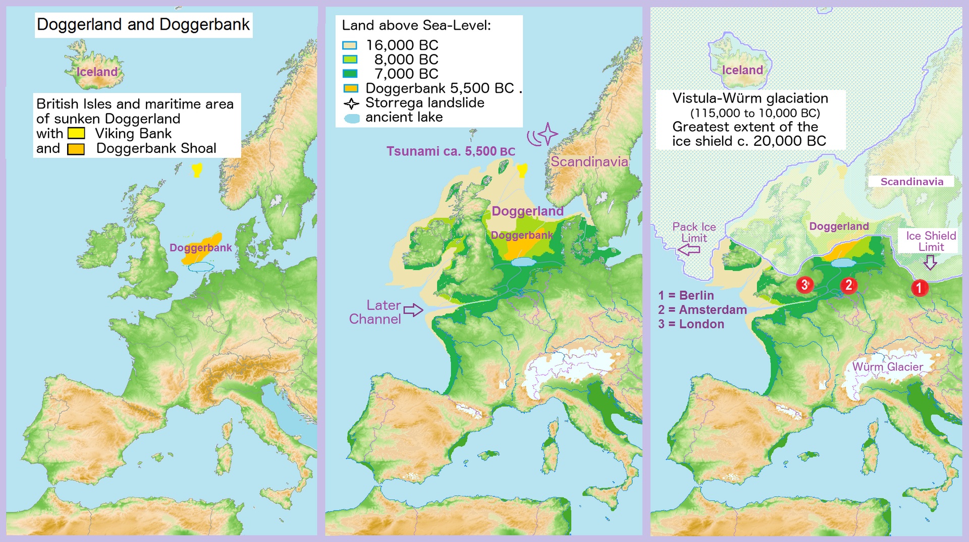
Doggerland is the name given to the now-submerged plain that once joined Britain to continental Europe across what is today the southern North Sea. Through the early Holocene it was not a land bridge but a rich, inhabited country of rivers, marshes, lakes and wooded hills, home to Mesolithic hunter-gatherers whose bone tools and worked flints still surface in the nets of North Sea trawlers. As the ice sheets melted, the sea rose and Doggerland shrank; and around 6150 BC a vast submarine landslide off Norway, the Storegga Slide, sent a tsunami sweeping across its low remnants. Whether that wave was the deathblow or merely one chapter in a long drowning is the crux of a lively modern debate.

See it on the globe →
The mainstream view

What archaeology says

Doggerland has moved from speculation to hard science largely through the work of Vincent Gaffney and the Europe's Lost Frontiers team at the University of Bradford, who used vast seismic-reflection datasets collected by the oil and gas industry to reconstruct the buried landscape in astonishing detail — its main river system (the 'Southern River'), estuaries, lakes and hills — across nearly 200,000 square kilometres of seabed. Sediment cores drilled from targeted spots have then been analysed for pollen, microfossils and, increasingly, ancient DNA extracted directly from the sediment (sedaDNA), building a picture of a genuine lived-in environment rather than an empty land bridge.

The Storegga tsunami, dated to around 6150 BC, is recorded as a distinctive sand layer within these cores; core ELF001A off Norfolk preserves the deposit, and multiproxy analysis confirms a marine inundation. The consensus is that Doggerland was progressively drowned by post-glacial sea-level rise, with Storegga delivering a sudden, locally catastrophic blow to communities on the remaining low ground. Notably, a 2020 study by Gaffney's group argued the tsunami did not instantly sever Britain from Europe: parts of Doggerland likely survived as an archipelago of islands for some centuries afterwards before final submergence. Recent sedaDNA work, including a 2026 study, has pushed the story back further, revealing that temperate forests of oak, elm and hazel with deer, boar, bear and aurochs colonised southern Doggerland far earlier than expected.

Key evidence cited
  • High-resolution seismic mapping of Doggerland's rivers, lakes and hills by Gaffney's Bradford team
  • Mesolithic bone and flint tools dredged from the seabed by North Sea trawlers
  • The Storegga tsunami sand layer dated to c. 6150 BC in core ELF001A off Norfolk
  • Sedimentary ancient DNA (sedaDNA) revealing forests and fauna of a genuinely inhabited landscape
  • A 2020 study showing Doggerland persisted as an archipelago for centuries after the tsunami
The alternative view

What the skeptics propose

Doggerland is unusual in that the 'alternative' reading is mostly a matter of emphasis and drama rather than a fringe claim — the science is robust, but the human story is genuinely underdetermined. One strand stresses the catastrophic framing: that Storegga was a megatsunami tens of metres high in places, that it struck a densely used coast, and that it may have killed a substantial share of the population and rendered much of the surviving land uninhabitable through salt poisoning of soils and freshwater. On this reading Doggerland offers a real, datable candidate for the kind of sudden coastal drowning that flood legends might remember, and a cautionary parallel for modern sea-level rise.

A second strand, popular in Atlantis-style speculation, casts Doggerland as a lost civilisation or the seed of northern deluge myths. Serious researchers push back: the Mesolithic people there were mobile hunter-gatherers, not builders of cities, and there is no evidence of monumental culture beneath the waves. Yet even the cautious scientists concede how much remains unknown — how many people lived there, exactly how they responded to the encroaching sea, and whether any oral memory of a vanished homeland could have survived the eight thousand years since. The tension between a slow, survivable drowning and a single overwhelming catastrophe is the live question, and the ongoing sedaDNA and coring campaigns are steadily deciding it.

Key evidence cited
  • Estimates of a Storegga wave tens of metres high striking a heavily used Mesolithic coast
  • Potential mass casualties and salt-poisoned land rendering survivors' territory uninhabitable
  • Doggerland as a real, datable candidate for the coastal drowning behind northern flood traditions
  • The scale of land lost — an entire country-sized landscape vanishing beneath the sea
  • Large gaps in knowledge about population size and human response leaving room for a catastrophic reading

Genuinely open questions

  1. How many people lived on Doggerland, and how catastrophic was the Storegga tsunami for them?
  2. How long did the surviving islands remain habitable before final submergence?
  3. Could any memory of the drowned homeland have survived in later oral tradition, or is that unknowable?

Worth knowing

A trawler working the Dogger Bank in 1931 hauled up a barbed antler harpoon point later dated to around 12,000 years old — the find that first proved people had lived on the floor of the North Sea.