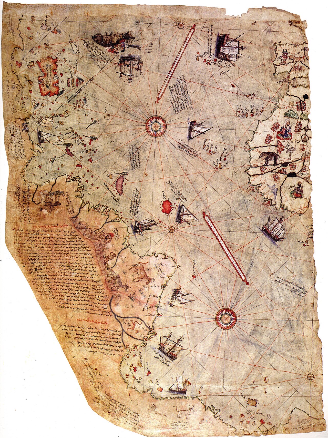
Lost Worlds · Topkapi Palace Library, Istanbul, Turkey (found there in 1929)

Piri Reis Map

The Ottoman admiral's chart that some say shows Antarctica — 300 years before its discovery

Mainstream: AD 1513, compiled from contemporary and classical chartsAlternative: Copied from source maps of an unknown civilisation, before c. 4000 BC41.01°, 28.98°

At a glance

Piri Reis Map
Photo: Piri Reis · Public domain

In 1929, during the conversion of Topkapi Palace into a museum, the German theologian Gustav Adolf Deissmann and Turkish scholars identified a fragment of a world map painted on gazelle-skin parchment, signed by the Ottoman admiral Piri Reis and dated 1513. It shows the Atlantic: the Iberian and West African coasts, the Caribbean, Brazil — and, at the bottom, a landmass sweeping eastward that Charles Hapgood later argued was Antarctica charted free of ice. Piri Reis's own marginal notes say he compiled it from about twenty older charts, including Portuguese maps and one obtained from a sailor who had voyaged with Columbus, which makes the surviving fragment a genuine treasure of early cartography regardless of the controversy.

See it on the globe →
The mainstream view

What archaeology says

Historians of cartography read the map as an impressive but entirely sixteenth-century compilation. Gregory McIntosh, whose book-length study The Piri Reis Map of 1513 remains the standard treatment, shows its Caribbean geography reproduces the distinctive errors of Columbus-era charts — Cuba drawn as part of a mainland, Hispaniola oriented like Japan on contemporary maps — exactly what you would expect from the captured Columbian source Piri Reis says he used.

The southern landmass is explained without Antarctica. Renaissance mapmakers routinely drew a speculative Terra Australis to balance the globe, and several scholars, including the geologist Steven Dutch, note that the 'Antarctic' coast reads naturally as the South American coastline bent eastward to fit the parchment — its labels even mention conditions and creatures matching Patagonia. The supposed match with the subglacial topography of Queen Maud Land, endorsed in a 1960 letter from USAF officer Harold Z. Ohlmeyer that Hapgood publicised, does not survive comparison with modern radar surveys of the bedrock, which show a coastline quite unlike the map's.

Mainstream scholars emphasise that Piri Reis was a superb, well-sourced compiler — his 1521 Kitab-i Bahriye sailing guide proves it — and that admiration for his real achievement is a better story than a lost civilisation.

Key evidence cited
  • Piri Reis's own notes list his sources: about twenty charts, including Ptolemaic, Arab and Portuguese maps and one from Columbus's voyages
  • The Caribbean section reproduces signature errors of Columbus-era cartography, betraying its true sources
  • Renaissance maps routinely showed a conjectural southern continent, Terra Australis, long before Antarctica's 1820 discovery
  • Modern radar surveys of Antarctica's subglacial bedrock do not match the map's southern coastline
  • Marginal notes on the southern landmass describe warm-climate details consistent with South America, not a polar coast
  • Antarctica has been glaciated for millions of years; ice cores show no ice-free coast within the span of human civilisation
The alternative view

What the skeptics propose

The alternative case was built by Charles Hapgood, a college history instructor, in Maps of the Ancient Sea Kings (1966). Hapgood argued that the map's southern coast matches Queen Maud Land as it would appear without its ice sheet, that the fragment preserves fragments of an ancient worldwide survey conducted by an unknown seafaring civilisation, and that these source charts — passed down through Alexandria and Constantinople — used sophisticated projections implying knowledge of spherical trigonometry and accurate longitude. He connected this to his earth-crust-displacement theory, for which Albert Einstein had earlier written a courteous foreword, proposing Antarctica was ice-free within the last several thousand years.

Hapgood's Antarctica reading was seeded by Arlington Mallery, a retired engineer who first made the claim in the 1950s, and was supercharged when Erich von Daeniken cited the map in Chariots of the Gods (1968) and when Graham Hancock made it a pillar of Fingerprints of the Gods (1995), tying it to a lost Ice Age culture. Rand and Rose Flem-Ath extended the argument to identify Antarctica with Atlantis itself.

Current status: the claim remains a fixture of lost-civilisation literature, though Hancock himself has since shifted emphasis to other evidence. No professional cartographic historian endorses the ice-free-Antarctica reading, but the map's genuine mysteries — which twenty source charts, and what did the lost Columbus map look like? — keep the debate alive.

Key evidence cited
  • Hapgood argued the southern coast aligns with Queen Maud Land's subglacial topography as known from 1949 seismic soundings
  • A 1960 letter from USAF Lt Col Harold Z. Ohlmeyer stated the resemblance to the seismic profile was remarkable
  • The map's overall accuracy across the Atlantic seemed to Hapgood too good for early sixteenth-century longitude methods
  • Piri Reis admitted copying much older charts, leaving room, advocates say, for sources of unknown antiquity
  • Einstein took Hapgood's crust-displacement mechanism seriously enough to write a foreword for his 1958 book
  • Graham Hancock and the Flem-Aths argue the map fits a wider pattern of anomalous early charts, such as the Oronteus Finaeus map of 1531

Genuinely open questions

  1. What happened to the roughly two-thirds of the original world map that is lost, and could it survive somewhere in the Topkapi archives?
  2. What exactly did the captured Columbus chart show, and will a copy ever be found?
  3. Which specific twenty source maps did Piri Reis use, and how far back did the oldest of them reach?
  4. Why does the map's southern landmass carry realistic-sounding coastal detail rather than the plain conjecture typical of Terra Australis?

Worth knowing

Piri Reis met a grim end unconnected to his maps: in about 1553, aged around 80, the admiral was beheaded in Cairo after refusing to continue an Ottoman naval campaign in the Persian Gulf.