Myth & Memory · Borth and Ynyslas, Cardigan Bay, Wales

Cantre'r Gwaelod & the Cardigan Bay Submerged Forests

A Welsh drowned-kingdom legend, and the very real prehistoric forest that surfaces from the sand after every big storm.

Mainstream: c. 4,500–6,000 years ago (submerged forest peat; drowned in the mid-Holocene)Alternative: Legend places the drowning in the 5th–6th century AD, in the lifetime of the mythical ruler Gwyddno Garanhir52.49°, -4.05°

At a glance

Cantre'r Gwaelod & the Cardigan Bay Submerged Forests
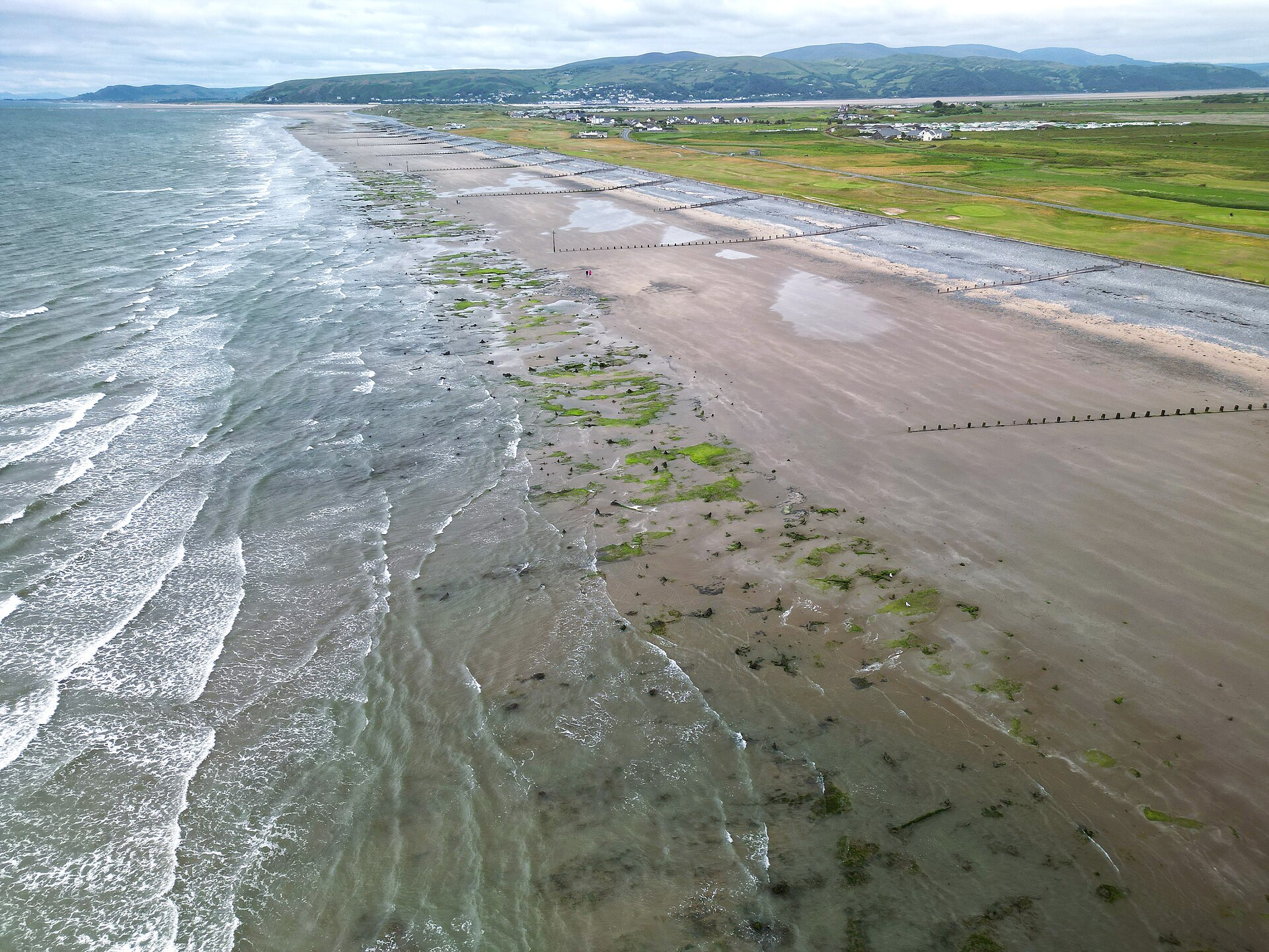
Photo: Llywelyn2000 · CC BY-SA 4.0

Cantre'r Gwaelod, the Lowland Hundred, is Wales's Atlantis: a fertile realm of sixteen cities said to have lain in what is now Cardigan Bay, protected from the sea by dykes and sluice gates until, one careless night, the waters broke through and drowned it forever. The legend has been told and sung for centuries, most famously in the poem of the bells of Aberdovey ringing beneath the waves. And along the same shoreline, between the seaside village of Borth and the dunes of Ynyslas, lies something the legend seems almost to describe: a submerged forest of blackened tree stumps, thousands of years old, that emerges from the beach at low tide and after storms strip away the sand.

See it on the globe →
The mainstream view

What archaeology says

To geologists and archaeologists the Borth and Ynyslas submerged forest is not a drowned kingdom but a drowned landscape, and a beautifully readable one. The stumps are the roots and lower trunks of oak, pine, alder, birch and hazel that grew on a coastal peat bog between roughly 6,000 and 4,500 years ago, when sea level was lower. As the post-glacial seas continued to rise through the mid-Holocene, the water table climbed, the bog spread and then the sea itself advanced, killing the trees and burying them in peat. The acidic, oxygen-starved peat preserved the wood, which is why the stumps still stand where they grew.

The site is more than dead trees. Preserved in the hardened peat are human and animal footprints, a scatter of burnt stone, wooden trackways and post alignments, and even a red deer antler — traces of Bronze Age people moving across a landscape now beneath the tide. This makes Borth a genuine archive of prehistoric coastal life and of the process of marine transgression, and it is protected accordingly. The mainstream reading is that the forest records slow, natural sea-level rise over generations, not a single catastrophic flood, and certainly not the sudden failure of any sea wall.

Where mainstream scholarship does engage the legend is through geomythology — the study of how real geological events survive in folklore. Researchers note that stories of drowned lands cluster precisely along coasts where such submerged forests and lost surfaces exist, and ask whether the tales encode a genuine, if heavily reworked, memory of ancestral land loss.

Key evidence cited
  • Tree stumps of oak, pine and alder radiocarbon-dated to c. 6,000–4,500 years ago, preserved in coastal peat
  • A clear geological sequence of rising water table, spreading bog and marine transgression drowning the forest
  • Preserved human and animal footprints, burnt stone and wooden trackways showing Bronze Age activity
  • The sarnau shown to be glacial moraines, not artificial causeways or sea walls
  • The drowning explained as gradual, generations-long sea-level rise rather than a single catastrophic flood
The alternative view

What the skeptics propose

The alternative reading is not pseudo-archaeology so much as a serious folkloric proposition: that Cantre'r Gwaelod is a real memory. Advocates of geomythology argue that oral tradition can preserve the outline of events far older than any written record, and that the recurring British and Welsh legends of drowned kingdoms — Cantre'r Gwaelod in Cardigan Bay, Llys Helig off the north coast, Lyonesse off Cornwall — map suspiciously well onto exactly those stretches of coast where prehistoric land really did vanish beneath the sea.

On this view the visible submerged forest is not merely consistent with the legend but may be its ultimate source: generations of people walking a beach studded with the stumps of a drowned woodland, sometimes glimpsing timber trackways or footprints in the peat, would have every reason to tell a story of a lost, populated land now under the waves. The sarnau — long ridges of boulder and gravel that run out into Cardigan Bay and are in fact glacial moraines — were folded into the legend as the ruined causeways or walls of the kingdom, giving the myth a tangible map. Some point to finds such as a preserved red deer skull and the human footprints as the kind of physical trace that could have seeded and sustained the tale.

The steelman of this position is careful: no one serious claims sixteen cities lie intact offshore, or that a 6th-century king really drowned in one night. The claim is that folklore is a form of long-range memory, and that the drowned-forest coasts of Wales are a test case for whether human stories can carry information across four or five thousand years. Sceptics counter that such legends are common worldwide, easily invented to explain any striking coastal ruin, and that matching a vague flood tale to a real forest proves nothing about transmission — the correspondence may be coincidence or later rationalisation.

Key evidence cited
  • The clustering of drowned-kingdom legends along coasts where prehistoric land really was submerged
  • The visible submerged forest at Borth as a plausible real-world source for the Cantre'r Gwaelod story
  • The sarnau ridges reinterpreted in folklore as the causeways and walls of the lost land
  • A preserved red deer skull and fossil footprints as tangible traces feeding the legend
  • The geomythological argument that oral tradition can preserve memory of ancestral land loss for millennia

Genuinely open questions

  1. Can folklore genuinely preserve the memory of a landscape lost 4,000–5,000 years ago, or are such tales later inventions?
  2. Why do drowned-kingdom legends cluster on exactly the British coasts with real submerged forests — memory, or coincidence?
  3. How much of the Bronze Age coastal landscape survives offshore, still buried under Cardigan Bay's sediments?

Worth knowing

The legend says you can still hear the bells of the drowned churches ringing under Cardigan Bay — and after big storms the tide really does uncover a 4,500-year-old forest that has been under the sand the whole time.