Myth & Memory · Adrar Plateau, near Ouadane, Mauritania

Richat Structure (Eye of the Sahara)

A 40-kilometre bullseye in the Sahara that the internet decided was Atlantis — and geologists insist is a very old, very dry volcano that never erupted.

Mainstream: c. 100 million years old (Cretaceous igneous dome, exposed by deep erosion)Alternative: c. 9600 BC (proposed as Atlantis, destroyed at the end of the Ice Age)21.12°, -11.39°

At a glance

Richat Structure (Eye of the Sahara)
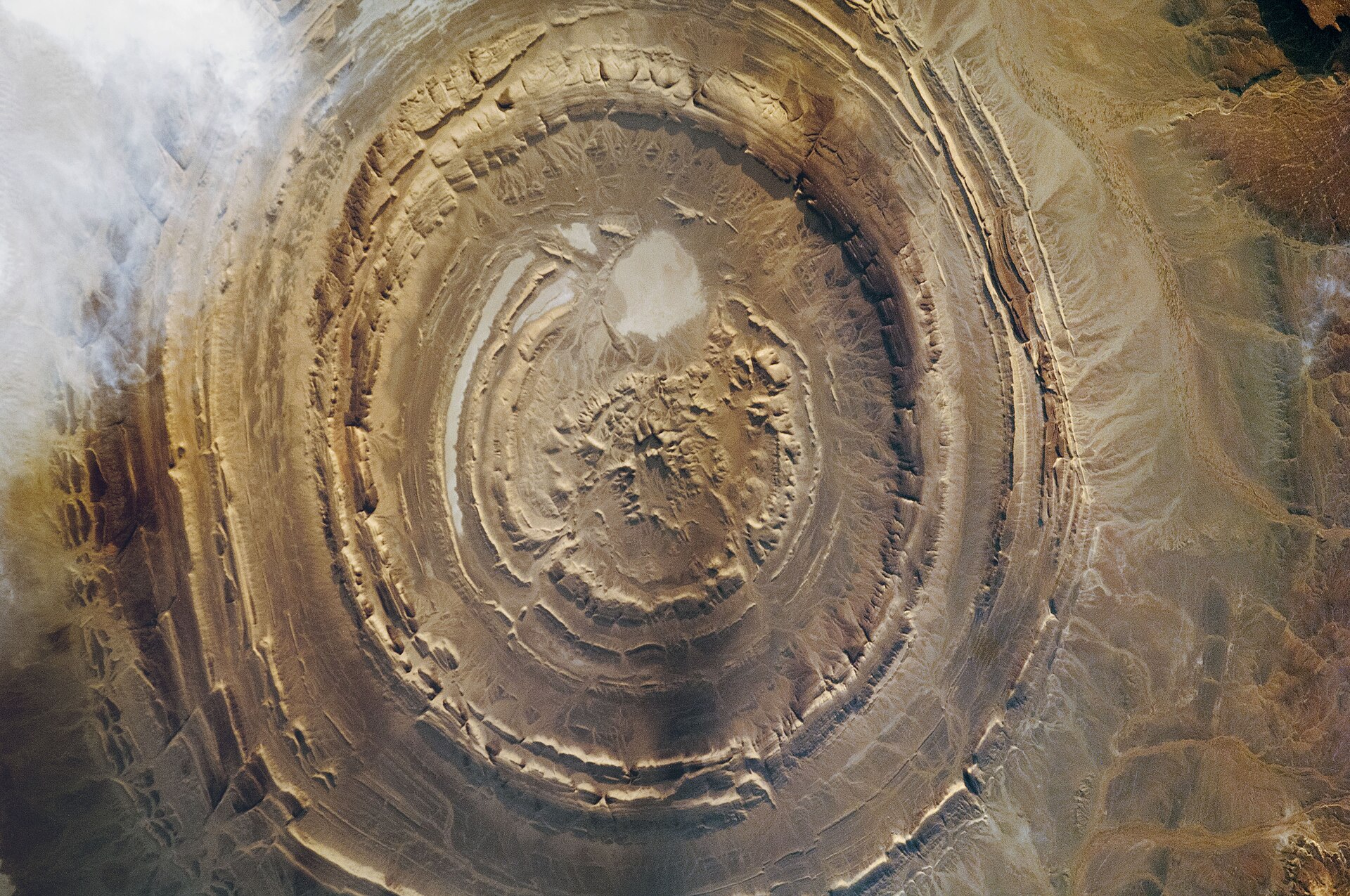
Photo: NASA (ISS Expedition 30) · Public domain

The Richat Structure, the 'Eye of the Sahara', is a set of vast concentric rock rings roughly 40 kilometres across in the Mauritanian desert, so large and so regular that it was barely recognised from the ground and became famous only when early astronauts used it as an orbital landmark. Once suspected to be a meteorite impact crater, it is now firmly classified as a deeply eroded geological dome. Since 2018 it has also been the internet's favourite Atlantis: a series of viral videos argued that its nested rings match Plato's description of the Atlantean capital, turning a remote geological curiosity into one of the most-discussed 'lost city' candidates on Earth and sending a stream of documentary crews to Ouadane.

See it on the globe →
The mainstream view

What archaeology says

Geologically, the Richat Structure is among the better-studied features of the Sahara. Work by Guillaume Matton and Michel Jébrak, among others, identified it as a Cretaceous alkaline igneous complex roughly 100 million years old: magma welling up beneath the crust domed the overlying sedimentary layers, hydrothermal fluids altered and collapsed the centre, and tens of millions of years of erosion then planed the dome flat, exposing alternating hard and soft strata as concentric ridges and valleys — a natural bullseye. The rings are simply the stumps of different rock layers; there is no impact shock evidence and no buried architecture. Crucially for the Atlantis question, the structure sits more than 400 metres above sea level and roughly 500 kilometres from the Atlantic coast, in a region of crust that has been tectonically stable for on the order of 100 million years. There is no geological mechanism by which it could have been submerged by the sea and re-exposed within human history, and no marine sediments of Holocene age drape it.

Archaeologically, the area is genuinely rich — but in the wrong way for a lost city. Surveys have documented exceptional surface accumulations of Acheulean and even pre-Acheulean stone tools along the wadis of the outer ring, where quartzite outcrops supplied raw material for hundreds of thousands of years of Palaeolithic tool-making. Yet despite this intense ancient human presence and superb desert preservation, not one wall, foundation, sherd scatter, harbour work or burial of an urban civilisation has ever been recorded there. Archaeologists note that a Bronze Age-style capital of the size Plato describes could not vanish from a landscape that faithfully preserved hand-axes a hundred times older.

Key evidence cited
  • Identified as a c. 100-million-year-old Cretaceous alkaline igneous dome (Matton and Jébrak), not an impact or artificial feature
  • Sits over 400 metres above sea level and about 500 kilometres inland — irreconcilable with Plato's harbour city drowned by the sea
  • The region's crust has been tectonically stable for roughly 100 million years, with no mechanism for recent submergence and re-emergence
  • Dense, well-preserved Acheulean and pre-Acheulean stone-tool sites ring the structure, yet zero urban archaeology has ever been found
  • The concentric rings are explained by differential erosion of alternating hard and soft rock strata around an eroded dome
The alternative view

What the skeptics propose

The modern claim was popularised from 2018 by Jimmy Corsetti of the YouTube channel Bright Insight, building on the documentary Visiting Atlantis by George S. Alexander and Natalis Rosen, and it deserves to be stated at full strength. Plato describes the Atlantean capital as alternating concentric rings of land and water; the Richat is a natural set of concentric rings whose outer diameter, proponents argue, is close to the roughly 23 kilometres implied by Plato's 127 stadia. Plato says mountains sheltered the city to the north — the Adrar highlands lie to Richat's north. Plato's Atlantis had elephants, springs and abundant water; North Africa in the early Holocene was the 'Green Sahara', with lakes, rivers, elephants and large human populations, and Richat sits amid dry riverbeds that once flowed. Plato places Atlantis opposite the Pillars of Heracles in the direction of the outer ocean, which a generous reading can stretch to Atlantic-facing West Africa. Proponents add that the end-of-Ice-Age cataclysm they favour — often tied to the Younger Dryas impact hypothesis — could have scoured the site with floodwaters, pointing to what they interpret as water-transported debris across the region.

The rebuttals are unusually decisive, which is why even many alternative-history enthusiasts have moved on. The elevation and distance from the sea contradict Plato directly: his Atlantis was a maritime power whose city ringed a harbour open to the ocean, and whose remains left shoals that still obstructed shipping in his own day — impossible for a landlocked plateau 400 metres up that has not been under the sea since long before dinosaurs went extinct. The ring dimensions only fit if one selects among Richat's many rings and rounds Plato's figures generously. The Green Sahara details are real but generic — they applied to millions of square kilometres, not to this spot — and the total absence of urban archaeology amid abundant preserved Palaeolithic material is the opposite of what a drowned metropolis would leave. Geologists including those responding directly to the videos note that Corsetti's scenario requires the structure to have been simultaneously coastal, submerged and then uplifted on timescales the region's stable geology rules out. As a test case in how to weigh a seductive visual match against physical evidence, Richat has become the standard classroom example.

Key evidence cited
  • Concentric ring form visually echoing Plato's alternating circles of land and water (Corsetti, Bright Insight)
  • Claimed diameter match between Richat's rings and Plato's 127-stadia figure for the outer ring of the capital
  • Mountains to the north (the Adrar), matching Plato's description of the city's sheltering highlands
  • Green Sahara conditions in the early Holocene: rivers, lakes and elephants in the wider region, as in Plato's account
  • Spreads of transported rock debris interpreted by proponents as evidence of a catastrophic flood event scouring the site

Genuinely open questions

  1. What did human occupation around the Richat Structure look like during the Green Sahara, and why has the area seen so little systematic excavation?
  2. How exactly did the hydrothermal collapse at the structure's centre unfold, and what does it record about Cretaceous rifting in West Africa?
  3. Why does the concentric-city image exert such a pull — and what would a rigorous archaeological survey of the rings actually find?

Worth knowing

The Eye of the Sahara is so hard to appreciate from the ground that it was essentially discovered by astronauts — Gemini crews in the 1960s used the giant bullseye as a navigation landmark, and it remains a favourite photographic target from the International Space Station.